
Interactive Office Maps: How They Work, What to Look for, and How Top Platforms Compare
Hybrid work has made the office a dynamic, unpredictable environment - and static floor plans were not built for it. When teams come in on different days, desks are unassigned, and layouts change regularly, employees need a live, visual tool to navigate the space and find what they need without friction.
According to a MapsIndoors analysis of 393 workplace management companies, 73.9% of user-focused workplace solutions already include an indoor map - and 100% of hybrid workplace platforms do, making it one of the most adopted features in the category and a baseline expectation for any team managing a hybrid office.
This article covers how interactive office maps work, what features to look for in workplace management software, how leading platforms compare, and how office heatmaps connect to space analytics.
TL;DR:
- Interactive office maps connect a visual floor plan to live booking data - showing real-time availability, colleague locations, and wayfinding directions
- Key features to look for include self-serve floor plan editing, booking from the map, multi-floor support, and Microsoft 365 or Teams integration
- YAROOMS, Skedda, Robin, Archie, and Kadence all include interactive maps - they differ on setup process, analytics depth, and Teams integration
- Office heatmaps are an analytics layer built on top of the map, showing which areas get used most based on booking and occupancy data
- Keeping the map updated, labeling spaces clearly, and embedding it in tools employees already use are the biggest drivers of adoption
What Is an Interactive Office Map?
An interactive office map is a live, clickable version of your office floor plan that employees can use to find, book, and navigate spaces in real time.
Unlike a static floor plan - which shows how the office is laid out but provides no live data - an interactive office map connects to your booking system and calendar, so what employees see on screen reflects what is actually available right now. You can:
- Find an available desk or meeting room and book it directly from the map
- Search for a colleague and see where they are sitting today
- Locate amenities like printers, phone booths, or kitchen areas
- Get turn-by-turn wayfinding directions to any space or person
- Check availability for a specific date and time before coming in
- View multiple floors or office locations in one interface
What Are the Main Types of Office Maps?
Office mapping tools fall into three categories, each serving a different primary use case.
| Map type | What it shows | Best used for | Typical devices |
|---|---|---|---|
| Digital directory map | Static floor plan with labeled spaces, amenities, and departments | Visitor orientation, building directories, signage | Lobby kiosks, digital signage screens, printed maps |
| Interactive map | Live floor plan with real-time availability, booking, colleague search, and wayfinding | Day-to-day employee navigation and space booking | Desktop browser, mobile app, room panels, desk signs |
| Wayfinding map | Live space status and turn-by-turn directions | In-office navigation for employees and visitors at entry points | Lobby displays, floor entry touchscreens, tablet stands |
Most workplace management platforms today provide all three as part of a unified system, with the interactive map at the core and kiosks pulling from the same live data.
What Are the Benefits of Interactive Office Maps?
Interactive office maps reduce friction for every type of office user - from daily hybrid workers to first-day hires and external visitors.
Navigation Efficiency for Hybrid Employees
Hybrid employees who come in two or three days a week often find a different seating arrangement each time. An interactive map gives them real-time visibility so they can find an available desk, locate their team, and get to work without asking anyone.
Hot Desking Visibility
In hot desking environments, employees need to see which desks are free before they sit down. A live map shows availability at a glance - color-coded by status - and lets employees reserve a specific spot in advance from their phone.
New Hire and Visitor Onboarding
New employees and office visitors spend disproportionate time figuring out where things are. Interactive maps with wayfinding directions reduce that friction from day one, without requiring a guided tour or a printed floor plan.
Informed Space Reallocation Decisions
When the map is connected to booking data, facilities managers can see which zones are consistently underbooked. That data informs decisions about repurposing space, adjusting desk ratios, or consolidating floors - before making physical changes.
Emergency Exit and Safety Awareness
A digital office map can display emergency exit routes, first aid locations, and evacuation assembly points - accessible on any device and always up to date when the office floor plan changes.
What Office Map Features Should You Look for in Workplace Management Software?
The right office map feature set goes well beyond a visual floor plan. When evaluating workplace management software, look for these capabilities:
- Real-time desk and room availability - spaces update instantly when a booking is made or cancelled, so employees never arrive at an occupied desk
- Colleague and amenity search - find a person, a printer, a phone booth, or a collaboration area by name or category directly on the map
- Turn-by-turn wayfinding directions - step-by-step navigation from any point to any destination, useful in large or multi-floor offices
- Multi-floor and multi-location support - manage floor plans across buildings and cities from a single interface
- Booking directly from the map - employees click a space on the map and confirm a reservation without switching to a separate booking screen
- Mobile, kiosk, and desktop access - the same map experience available on a smartphone, browser, or physical kiosk in the lobby
- Microsoft 365 / Google Calendar / Teams integration - bookings made on the map sync automatically to calendar and can be initiated directly from Teams or Outlook
- Self-serve floor plan editing - admins can upload and update floor plans without submitting requests to a vendor or waiting for an implementation team
How Do You Create an Interactive Office Map?
Setting up an interactive office map in a workplace management platform typically takes less than a day for a single-floor office and a few days for a multi-floor or multi-location setup.
- Upload your floor plan - most platforms accept PNG, JPG, PDF, or CAD files. A high-resolution image of your floor plan is enough to get started.
- Tag desks, rooms, and points of interest - click on each space in the map editor (or similar tool) and assign it a name, type, capacity, and any relevant amenities.
- Connect your calendar integration - link Microsoft 365 or Google Calendar so that existing room bookings populate on the map immediately.
- Set booking rules and permissions - define who can book which spaces, how far in advance, and under what conditions (approval required, time limits, neighborhood restrictions).
- Publish to web, mobile, and kiosk - once the map is live, employees access it from the platform’s web app, mobile app, or any kiosk display you have deployed.
- Train employees and gather feedback - a short walkthrough or video tutorial is enough for most teams. Collect feedback in the first two weeks and adjust POI labels or booking rules based on what causes confusion.
How Do the Leading Workplace Management Platforms Compare on Office Mapping?
All major workplace management platforms include an interactive office map, but they differ significantly on floor plan setup, editing flexibility, booking integration, and analytics depth.
| Platform | Map setup | Self-serve editing | Booking from map | Neighborhoods / zones | Space analytics |
|---|---|---|---|---|---|
| YAROOMS | Admin uploads floor plan, tags spaces in edit mode | ✅ Fully self-serve | ✅ Yes, including via desktop, mobile app, kiosk, or Microsoft Teams | ✅ Yes, with capacity limits per area | ✅ Heatmaps from booking data, no sensors required |
| Skedda | Submit any layout file; Skedda builds the map within 24 hours | ✅ Admins update spaces after initial setup | ✅ Under 30 seconds from browser, mobile, Teams, or Slack | ✅ Yes, with per-neighborhood access rules | ✅ Utilization insights; WiFi and QR check-in for actual occupancy |
| Robin | Submit PDF/JPG/PNG to Robin’s Maps team (2–3 days); CAD auto-tracing available | ⚠️ Map editor for adjustments; new maps via Robin support | ✅ Yes, including from kiosk | ✅ Color-coded neighborhoods with labels | ✅ Real-time view of people, spaces, and resources |
| Archie | Upload PNG or JPG; drag-and-drop editor | ✅ Fully self-serve, update anytime | ✅ One-click from map | ✅ Yes, with zones and booking policies per area | ✅ Desk and area utilization, presence by department |
| Kadence | Admin configures layout; no re-upload required for changes | ✅ Admins update layouts without IT | ✅ Yes, integrated with desk booking | ✅ Layered views for teams, amenities, and zones | ✅ Space utilization by building, floor, desk, and time; peak occupancy tracking |
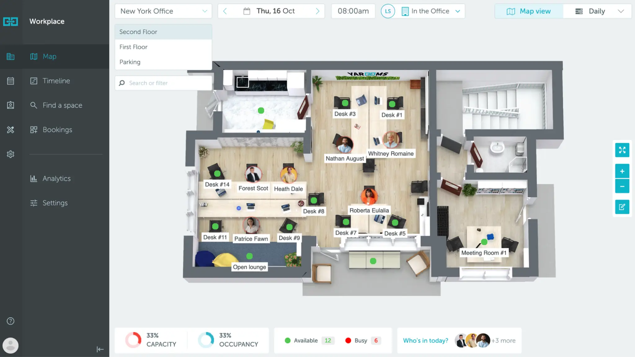
How Does YAROOMS Interactive Office Map Work?
YAROOMS includes a fully self-serve interactive office map - admins can set up, edit, and maintain the entire map without vendor involvement. For larger or more complex deployments, YAROOMS support is available, but most organizations handle everything independently from day one.
The setup process works like this:
- Upload your floor plan - add a floor plan image for each floor or location. The map becomes the visual canvas everything else is built on.
- Switch to Edit Mode - a dedicated edit mode lets admins add, move, and delete spaces directly on the map by clicking or dragging. No separate configuration panel needed.
- Add spaces - click any spot on the floor plan to place a desk, meeting room, or other shared resource. Assign it a name, type, capacity, amenities, and booking rules. New spaces appear on the live map instantly.
- Define areas - draw zones on the map to group desks into neighborhoods or departments, and set capacity limits per area. Useful for managing how many people can book into a given zone on the same day.
- Add Points of Interest - beyond bookable spaces, tag locations like coffee stations, printers, restrooms, and first-aid kits with custom icons and descriptions. POIs appear on the map for all users and help employees and visitors navigate independently without asking anyone.
Once live, employees use the map to check real-time and future availability, search for colleagues, book a desk or room with a single click, mark favourite spaces, and get directions to any location on the floor plan.
The same map is accessible from the web app, mobile app, and Microsoft Teams - where Yarvis, the YAROOMS AI agent, can find and book spaces through a simple chat message.
How Does Skedda’s Office Map Work?
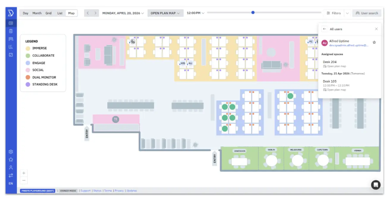
Skedda’s approach to office maps starts with a concierge setup: submit any layout file - architectural PDF, CAD drawing, PNG, or a hand-drawn sketch - and Skedda’s team delivers a custom interactive map within 24 hours. Once the map is live, admins manage spaces themselves with no IT tickets or re-upload cycles.
The map supports a mix of permanently assigned desks and bookable hot desks on the same floor plan - assigned desks show the occupant’s name and photo, bookable desks show live availability.
Employees book in under 30 seconds from a browser, the mobile app, Microsoft Teams, or Slack. Skedda also confirms actual occupancy through WiFi-based presence detection and QR code check-in, and auto-releases spaces when no one checks in, keeping the map accurate and preventing ghost bookings.
How Does Robin’s Office Map Work?
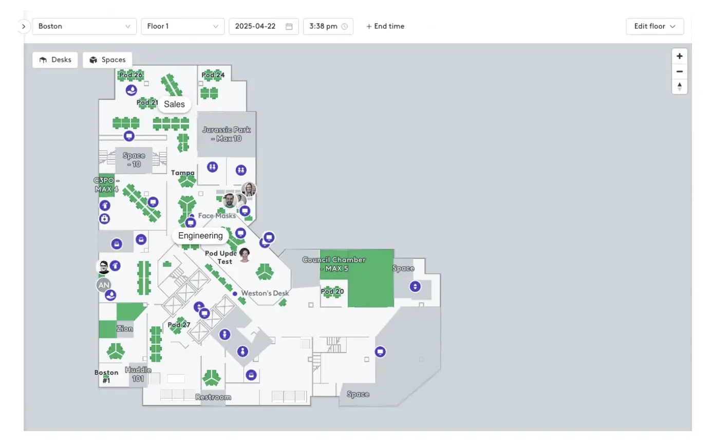
Robin offers three ways to get a floor plan into the platform: submit a PDF, JPG, or PNG to Robin’s Maps team for conversion within 2–3 business days; upload a CAD file for automatic tracing directly in the map editor; or draw a map manually. Once the base map is in place, admins use Robin’s map editor to add and adjust desks, spaces, and furnishings.
The map supports color-coded team neighborhoods with labels, making it easy for employees to find their team zone and navigate the office.
Employees can book from the map on desktop, mobile, or kiosk, and the map provides a real-time view of how people, spaces, and resources are being used across the office. Robin also supports points of interest on the map for additional navigation context.
How Does Archie’s Office Map Work?
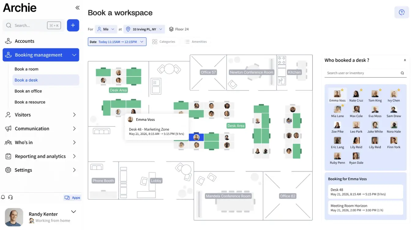
Archie’s interactive floor plans are fully self-serve from the start. Admins upload a PNG or JPG floor plan and use a drag-and-drop editor to place desks, rooms, zones, and amenities directly on the map.
Each workspace can include photos, descriptions, amenities, and booking policies, and layouts can be updated at any time without a design team. The map supports both assigned seating and flexible hot desking, and employees see who is in and where they are sitting in real time. Booking is one click from the map.
Archie’s analytics layer shows which desks and areas are used most, tracks presence by department, and provides occupancy trends to help facilities teams spot patterns and optimize layouts.
How Does Kadence’s Office Map Work?
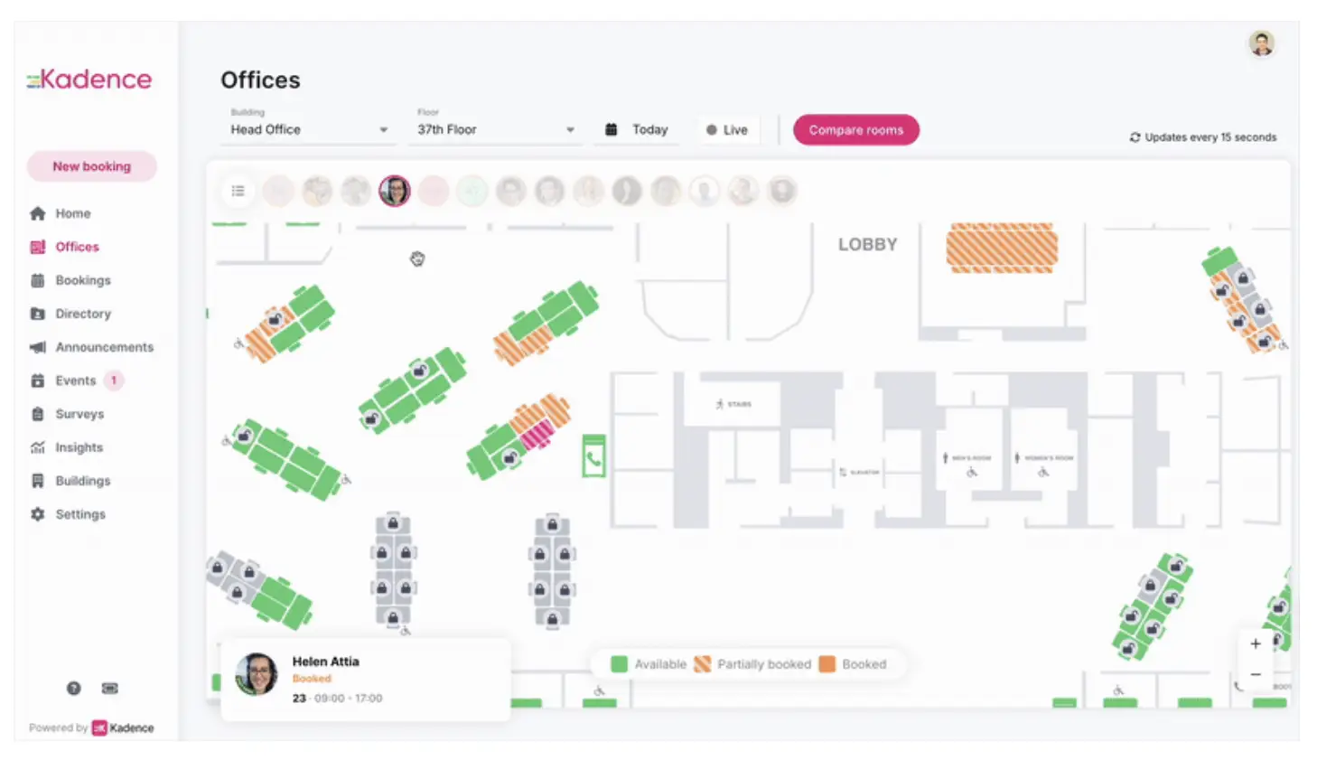
Kadence’s interactive office floorplan is designed around hybrid team coordination. The map shows clickable desks and rooms with real-time availability, and employees can see who is sitting where and reserve a space directly from the floor plan without switching between apps.
Admins can update layouts and seat assignments without re-uploading files or involving IT. The map supports layered views for teams, amenities, neighborhoods, and zones, so employees can filter by what is most relevant to their workday.
At the enterprise level, Kadence connects the floorplan to occupancy data and scenario planning tools, allowing leadership to make decisions about space allocation, team distribution, and office footprint across multiple buildings or regions.
What Are the Best Practices for Using Interactive Office Maps?
Getting value from an interactive office map depends as much on how you manage it as on the software you choose.
Keep the Map Updated in Real Time
An outdated map erodes trust faster than no map at all. When desks move, rooms get repurposed, or a new floor opens, the map should reflect that the same day. Platforms with self-serve editing (for example, YAROOMS) make this a five-minute task rather than a vendor request.
Use Clear POI Labels and Signage
Label every point of interest the way employees actually refer to it - “The Big Kitchen” rather than “Breakout Area 3B.” Consistent naming between the digital map and physical signage eliminates the most common source of navigation confusion.
Optimize Accessibility Across Devices
Ensure the map is accessible from the lobby kiosk for walk-ins, from the mobile app for employees planning their commute, and from a desktop browser for those booking ahead. A map that only works well on one device type sees lower adoption.
Train Employees and Encourage Adoption
A brief onboarding session - showing employees how to find a desk, locate a colleague, and get directions - is enough for most teams. Adoption improves further when the map is embedded in tools employees already use daily.
For example, YAROOMS addresses this directly through its native Microsoft Teams integration, where employees can access the office map and book spaces without leaving Teams - and use Yarvis, the AI agent, to find and reserve a space through a simple chat message.
How Do Office Heatmaps Work?
Office heatmaps are an analytics layer built on top of your interactive map that visualizes which desks, rooms, and zones are used most (and which go unused).
The data source is your booking system. Every desk reservation, room booking, and check-in generates an occupancy data point. Over time, those data points accumulate into patterns that the platform renders as a color gradient on your floor plan: warmer colors (red, orange) indicate high usage; cooler colors (blue, green) indicate low usage.
What facilities managers can read from a heatmap:
- Which desks or zones are consistently at full capacity - candidates for expansion or priority access rules
- Which areas are chronically underused - candidates for repurposing as collaboration zones, quiet rooms, or storage
- Peak occupancy hours across the day or week - useful for managing cleaning schedules, catering, and HVAC costs
- Which floors or neighborhoods see the most activity when specific teams are in the office
YAROOMS generates heatmaps directly from desk and room booking data - no occupancy sensors or additional hardware required.
FAQ: Interactive Office Maps
What Is the Difference Between an Interactive Office Map and a Floor Plan?
A floor plan is a static architectural drawing that shows how an office is laid out. An interactive office map connects that layout to live booking data, showing real-time desk and room availability, colleague locations, and wayfinding directions - and allowing employees to make reservations directly from the visual interface.
What Is Indoor Mapping Software for Offices?
Indoor mapping software for offices converts a physical floor plan into a digital, navigable map that employees can use to find spaces, people, and amenities. In a workplace management context, it refers to the map feature within platforms like YAROOMS, Robin, or Skedda - rather than standalone indoor navigation products designed for airports or large venues.
What Is the Difference Between Office Mapping Software and a Workplace Management Platform?
Office mapping software is a standalone tool focused specifically on converting floor plans into navigable digital maps - typically used for wayfinding, indoor navigation, and space visualization. A workplace management platform like YAROOMS, Robin, or Skedda includes an interactive office map as one feature within a broader system that also covers desk and room booking, calendar integrations, visitor management, analytics, and access controls. The map in a workplace management platform connects directly to live booking data, making it operational rather than purely navigational.
Which Tools Show an Office Seating Map?
Workplace management platforms including YAROOMS, Skedda, Robin, Archie, and Kadence all include interactive office seating maps. Each shows real-time desk availability, colleague locations, and room status on a visual floor plan. They differ on analytics depth, Teams integration, and how much vendor involvement is required to set up and edit maps.
How Does an Interactive Office Map Help With Hot Desking?
In a hot desking environment, no desk is permanently assigned - so employees need to see which desks are free before choosing one. An interactive map shows available desks in real time, color-coded by status, and lets employees reserve a specific desk in advance from their phone or laptop. This eliminates the daily uncertainty of arriving at the office and finding no suitable space.
Can an Interactive Office Map Integrate With Microsoft Teams?
Yes. Most workplace management platforms integrate with Microsoft Teams, allowing employees to check office availability and make bookings without leaving the Teams interface. YAROOMS offers a native Teams integration where Yarvis, the AI workplace agent, handles space booking through a conversational chat interface - no separate app required.
How Do I Build an Interactive Office Map for My Workplace?
Upload your floor plan to a workplace management platform, tag desks and rooms, connect your calendar integration, set booking rules, and publish. For example, in YAROOMS, the entire setup is self-serve - and a basic single-floor map can be live within a few hours.
Workplace of the future. Today.
See how YAROOMS integrates with Microsoft 365 to create a seamless workspace booking experience.